
Page 257 - Special Topic Session (STS) - Volume 4
P. 257
STS583 Mariana K. et al.
3. To produce new “geospatial statistics” based on geospatial data sources
such as geographical databases, satellite images, etc. and the combination
of these data sources together or with existing statistics. Geographical
information Systems (GIS) and related methodologies are key elements to
enable the production of geospatial statistics. Such geospatial statistics
could address the emerging needs for new products in thematic domains
with a strong spatial component (e.g. transport, agriculture, energy and
population).
2. Methodology
Embedded into a long-term strategy within Eurostat and the ESS to
integrate spatial information and statistics, in 2010 Eurostat launched a series
of projects–at both the European and national levels.
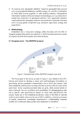
2.1 European Level – The GEOSTAT projects
2017 - 2019
GEOSTAT 3 - A 2020 - 2022
European version GEOSTAT 4
of the Statistical (planned)
2015 - 2016 Geospatial
GEOSTAT 2 - point Framework
based geocoding (completed)
infrastructure for
statistics
(completed)
2010 - 2014
GEOSTAT 1 - EU
wide
population grid
(completed)
Figure 1. Development of the GEOSTAT projects over time
The first project in the series, as seen in Figure 1, was related to the 2011
Census and aimed to develop a vision and methodological foundation at
geocoding various population characteristics into a 1km2 grid dataset. Grid
data availability varied across countries. Not all countries in the EU were at the
same level. Some countries provided data on grids, while several relied on
other methods. The pre-conditions and possibilities for disaggregating data
led to specific data specifications. Based on these data specifications the
project made use of the Statistical production chain in the NSIs to identify
relations and enable coherence by use of GIS. In addition, common processes
of quality assessment, knowledge dissemination, confidentiality, business
models and continuous data update were addressed or identified.
246 | I S I W S C 2 0 1 9