
Page 259 - Special Topic Session (STS) - Volume 4
P. 259
STS583 Mariana K. et al.
provided to NSIs from 2012 to 2018 to work on country specific objectives.
Examples of such objectives were: i) integration of geospatial and statistical
information during the statistical production process; ii) processes required for
continuous, (semi-) automated, regular updates of GIS under the aspect of
unique national identifier systems; iii) create new information in the open data
initiative and the usage of Big Data streams; iv) investigate spatial and
temporal distribution of statistics; v) the usage of Earth observation (e.g.
Copernicus Sentinel products) for statistics, and SDG monitoring; or; vi) access
to INSPIRE data (e.g. addresses, administrative units, etc.) and services
provided by the NMCAs.
3. Results
3.1 European Level – GEOSTAT Projects
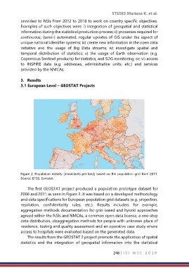
Figure 2. Population density (inhabitants per km2) based on the population grid from 2011.
Source: EFGS, Eurostat
The first GEOSTAT project produced a population prototype dataset for
2006 and 2011 as seen in Figure 2. It was based on a developed methodology
and data specifications for European population grid datasets (e.g. projection,
resolution, confidentiality rules, etc.). Results included, for example,
aggregation methods documentation for grid-based and hybrid approaches
agreed within the NSIs and NMCAs, a common open data licence, a one-stop
data distribution, disaggregation methods for people with unknown place of
residence, testing and quality assessment and an operative case study where
access to hospitals were evaluated based on the generated data.
The results from the GEOSTAT 2 project promote the application of spatial
statistics and the integration of geospatial information into the statistical
248 | I S I W S C 2 0 1 9