
Page 261 - Special Topic Session (STS) - Volume 4
P. 261
STS583 Mariana K. et al.
and civil engineering for example, but also to support national policies with
spatial analyses. A key element of the ESS geospatial data strategy is also to
support European policies with increased availability and utilisation of these
geographical datasets at the European level.
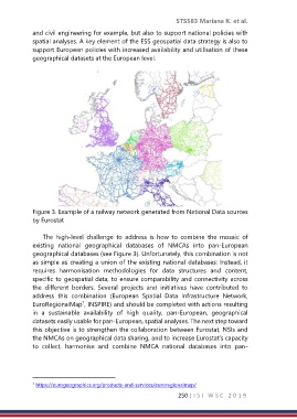
Figure 3. Example of a railway network generated from National Data sources
by Eurostat
The high-level challenge to address is how to combine the mosaic of
existing national geographical databases of NMCAs into pan-European
geographical databases (see Figure 3). Unfortunately, this combination is not
as simple as creating a union of the existing national databases: Instead, it
requires harmonisation methodologies for data structures and content,
specific to geospatial data, to ensure comparability and connectivity across
the different borders. Several projects and initiatives have contributed to
address this combination (European Spatial Data Infrastructure Network,
1
EuroRegionalMap , INSPIRE) and should be completed with actions resulting
in a sustainable availability of high quality, pan-European, geographical
datasets easily usable for pan-European, spatial analyses. The next step toward
this objective is to strengthen the collaboration between Eurostat, NSIs and
the NMCAs on geographical data sharing, and to increase Eurostat’s capacity
to collect, harmonise and combine NMCA national databases into pan-
1 https://eurogeographics.org/products-and-services/euroregionalmap/
250 | I S I W S C 2 0 1 9