
Page 262 - Special Topic Session (STS) - Volume 4
P. 262
STS583 Mariana K. et al.
European, geographical datasets following, for example, the UN-GGIM:
2
Europe core data recommendations .
The main benefit for Eurostat is to increase its capacity to produce and
update comparable geospatial statistics across Europe. Such geospatial
analytics are regularly produced by European Commission policy DGs
(Poelman & Dijkstra 2015, Poelman & Ackermans 2017). As part of its
geospatial strategy, Eurostat also takes a lead in the production of such
geospatial statistics and include them in its regular data catalogue.
3.3 Merging statistics and geospatial information at national level
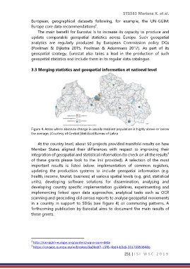
Figure 4. Areas where absolute change in usually resident population is highly above or below
the average; (Courtesy of Central Statistical Bureau of Latvia
At the country level, about 50 projects provided manifold results on how
Member States aligned their differences with respect to improving their
3
integration of geospatial and statistical information (to check on all the results
of these grants please look to the link provided). A selection of the most
important results is listed below: implementation of common registers,
updating the production systems to include geospatial information (e.g.
health, income, tourist, business) at various spatial levels (e.g. grid, statistical
units), developing software solutions for dissemination, analysing and
developing country specific implementation guidelines, experimenting and
implementing linked open data approaches, analytical tasks such as OCR
scanning and geocoding old census reports to analyse geospatial movements
in a country in support to SDGs (see Figure 4) or commuting patterns. A
forthcoming publication by Eurostat aims to document the main results of
these grants.
2 http://un-ggim-europe.org/content/wg-a-core-data
3 https://circabc.europa.eu/w/browse/9a3fadf7-19f6-4bd4-b3cb-30179950648b
251 | I S I W S C 2 0 1 9