
Page 270 - Special Topic Session (STS) - Volume 4
P. 270
STS583 Yakob M. S.
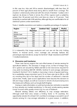
in this case too, Asia and Africa remain disadvantaged, with less than 20
percent of their agricultural areas being able to benefit from coverage. The
situation is dramatically enhanced with the arrival of Sentinel 1 (radar) and 2
(optical). As shown in Table 2, below, five of the regions reach a suitability
greater than 90 percent and Africa and Asia are close to 70 percent. Total
suitability is reached with VHR satellites, although they are unaffordable for all
statistical systems under examination.
Table 2. Satellite resolutions and relative compatible percentage of cropland
Region Spot/ Sentinel 1&2 Landsat8 Modis/
Rapideye /AWiFS Sentinel 3
Africa 100 69 18 3
Middle East 100 92 27 2
Asia 100 67 19 6
Central and South 100 97 74 29
America 100 99 75 29
Europe
North America 100 100 92 39
Oceania 100 100 92 66
World 100 85 53 21
It is noteworthy that image resolution and cost are not the only limiting
factors. In tropical zones, cloud coverage can seriously hamper the
percentages reported above, except for Sentinel 1 (high-resolution) and RISAT
1 (mediumresolution).
4. Discussion and Conclusion
Three main factors support the cost-effectiveness of remote sensing for
agricultural statistics. The decrease in image prices, as free-of-charge long-
term systems are secured by NASA and ESA at the resolutions required for
crop yield monitoring (METOP, MODIS, Sentinel 3) and acreage estimation
(Landsat 8, Sentinel 1 & 2). Quality is improving in terms of guaranteed long-
term availability, image resolution (up to 10 m), frame size (up to 290 m x 290
m), revisiting time (up to five days) and the number of radiometric channels
(above ten). Finally, open-source applications have become the standard in
GIS and image analysis, as well as in access to remote cloud processing tools
(hardware and software, such as Google Earth Engine).
Having an early information on yield and production estimates is essential
to food security and market monitoring. To this end, remote sensing assures
timely forecasts while greatly minimizing the cost of fieldwork.
Remote sensing attains cost efficiency in crop acreage estimation.
Although small field sizes remain a limiting factor in 70 countries, the
opportunity remains for at least 125 countries to envisage a successful use of
remote sensing for crop acreage estimation in a given season. In addition,
259 | I S I W S C 2 0 1 9