
Page 346 - Contributed Paper Session (CPS) - Volume 6
P. 346
CPS1958 Zaid AlQadhi et al.
3. Result
The results of data extraction methods, applied methodology and field
verifications deduced that each active meter represents one farm or one
residential unit – based on the unit use stated in the meters data management
system- and belongs administratively to the geo-location of the meter.
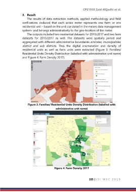
The outputs included two residential datasets for 2013/2017 and two farm
datasets for 2013/2017 as well. The datasets were spatially joined and
aggregated with different administrative boundaries emirates, municipalities,
district and sub districts. Thus the digital enumeration and density of
residential units as well as farm units were extracted (Figure 3: Families/
Residential Units Density Distribution (labelled with administrative unit name)
and Figure 4: Farm Density 2017).
Figure 3: Families/ Residential Units Density Distribution (labelled with
administrative unit name)
Figure 4: Farm Density 2017
335 | I S I W S C 2 0 1 9