
Page 185 - Special Topic Session (STS) - Volume 1
P. 185
STS 423 Avery S. et al.
online analytics (Han et al. 2012). Within NASS, CDL products have been used
in a variety of research and operational applications, including masking crop
extent for yield assessments (Johnson 2012), disaster assessments (Boryan et
al. 2018), area frame stratification (Boryan and Yang 2017), improving
estimates for the number of farms at the state and national-levels, and June
Area Survey (JAS) imputation. Monitoring U.S. agriculture is important for
food security and the CDL program provides a consistent geographical extent
and spatial resolution over the past eleven years serving that purpose.
The original purpose of the CDL program was to generate acreage
estimates of major commodities to reduce sampling error at the state,
agricultural statistical district, and county-levels for internal NASS use by the
Agricultural Statistics Board (Allen and Hanuschak 1988). The CDL is a
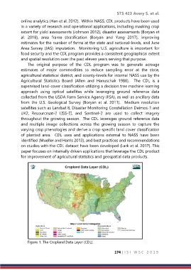
supervised land-cover classification utilizing a decision tree machine learning
approach using optical satellites while leveraging ground reference data
collected from the USDA Farm Service Agency (FSA), as well as ancillary data
from the U.S. Geological Survey (Boryan et al. 2011). Medium resolution
satellites such as Landsat 8, Disaster Monitoring Constellation Deimos-1 and
UK2, Resourcesat-2 LISS-III, and Sentinel-2 are used to collect imagery
throughout the growing season. The CDL leverages ground reference data
and multiple image collections across the growing season to capture the
varying crop phenologies and derive a crop-specific land cover classification
of planted area. CDL uses and applications external to NASS have been
identified (Mueller and Harris 2013), and best practices and recommendations
on studies with the CDL dataset have been developed (Lark et al. 2017). This
paper focuses on internally driven applications that leverage the CDL product
for improvement of agricultural statistics and geospatial data products.
Figure 1: The Cropland Data Layer (CDL).
174 | I S I W S C 2 0 1 9