
Page 223 - Special Topic Session (STS) - Volume 3
P. 223
STS541 Arturo B. E.
The information is grouped or subdivided by type of event: Climatological,
Geophysical, Hydrological, Climatic, Man-made, Organic, Biological, Chemical,
Technological and Social-Natural.
In the presence of an accident or natural disaster, the affected federal
entities are identified, with the purpose of initiating the analysis of the
information already available on the site. After, the statistical and geographical
3
information is sent to registered users on the site .
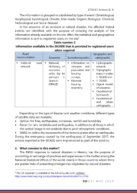
Table number 2
Information available in the SICADE that is provided to registered users
when required
Road Geographic and
communication Economic Sociodemographic cartographic
▪ National road ▪ National ▪ Information on ▪ Hydrographic
network. dictionary of censuses and network
economic population and ▪ Topographic
units, (by its housing maps in scales
acronym in surveys. 1: 50,000 and
Spanish ▪ National ▪ 1: 20,000.
DENUE). housing ▪ Digital model
inventory. of elevation.
▪ Geostatistical
framework.
▪ Geostatistical
and urban
cartography
Depending on the type of disaster and weather conditions, different types
of satellite data are available:
• Optical: for fires, earthquakes, volcanoes, rainfall and landslides.
• Radar: for rain, landslides and earthquakes, in addition to all those in which
the optical image is not available due to poor atmospheric conditions.
• GNSS: to define the movements of the tectonic plates after an earthquake.
During the emergency caused by the earthquakes of September 2017, the
actions expected in the SICADE were implemented as part of the solution.
4. What remains in this matter?
The INEGI response to natural disasters in Mexico, has the purpose of
promoting an exchange of practices and experiences in the matter among the
National Statistical Offices of the world, mainly in those countries where there
are greater risks of presenting emergencies originated by natural disasters.
The full statement is available at the following electronic address:
3
http://www.beta.inegi.org.mx/app/saladeprensa/noticia.html?id=3769
212 |I S I W S C 2 0 1 9