
Page 241 - Special Topic Session (STS) - Volume 4
P. 241
STS583 Daniel C.
degradation, and to develop location-specific assessments of risk and the
costs and benefits of intervention.
Degradation to ecosystem condition is defined in the System of
Environmental-Economic Accounts Central Framework (ibid) as adverse
changes to the condition (or capacity) of ecosystems to deliver ecosystem
services. This capacity depends on a complex interplay of natural processes
that create habitats in support of life and life-supporting conditions.
3. Geographic Data Integration
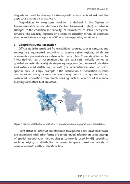
Official statistics produced from traditional sources, such as censuses and
surveys are aggregated according to administrative regions, which are
represented geospatially as polygons (or vector files). These statistics can be
integrated with earth observation data sets data sets (typically derived as
gridded, or raster data sets) via simple aggregations (in the case of grid data)
and extrapolated distribution of data (for administrative-based or point-
specific data). A simple example is the distribution of population statistics
calculated according to censuses and surveys into a grid system utilizing
correlated information from remote sensing, such as locations of residential
buildings and other built-up areas.
Figure 1. Sample distribution of district level population data using grid-based assimilation
Point statistics (information referenced to a specific point location) likewise
are assimilated with other forms of georeferenced information using a range
of spatial extrapolation methodologies commonly used by GIS specialists,
such as kriging or distribution of values in space based on models of
correlations with earth observation data.
230 | I S I W S C 2 0 1 9