
Page 242 - Special Topic Session (STS) - Volume 4
P. 242
STS583 Daniel C.
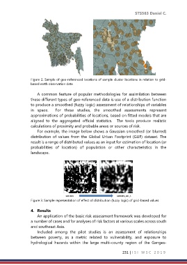
Figure 2. Sample of geo-referenced locations of sample cluster locations in relation to grid-
based earth observation data
A common feature of popular methodologies for assimilation between
these different types of geo-referenced data is use of a distribution function
to produce a smoothed (fuzzy logic) assessment of relationships of variables
in space. For these studies, the smoothed assessments represent
approximations of probabilities of locations, based on fitted models that are
aligned to the aggregated official statistics. The tools produce realistic
calculations of proximity and probable areas or sources of risk.
For example, the image below shows a Gaussian smoothed (or blurred)
distribution of values from the Global Urban Footprint (GUF) dataset. The
result is a range of distributed values as an input for estimation of location (or
probabilities of location) of population or other characteristics in the
landscape.
GUF100m GUF100m_sm1_5
Figure 3. Sample representation of effect of distribution (fuzzy logic) of grid-based values
4. Results
An application of the basic risk assessment framework was developed for
a number of cases and for analyses of risk factors at various scales across south
and southeast Asia.
Included among the pilot studies is an assessment of relationships
between poverty, as a metric related to vulnerability, and exposure to
hydrological hazards within the large multi-county region of the Ganges-
231 | I S I W S C 2 0 1 9