
Page 319 - Special Topic Session (STS) - Volume 4
P. 319
STS637 Ronald W. J.
Examples of data science projects – (1) Mapping the urban forest
In September 2018, data scientists of the ONS Campus published the
results of their project “Mapping the urban forest at street level”. They
developed an experimental method for estimating the density of trees and
vegetation present at 10 meter intervals. The approach uses images sampled
from Google Street View as the input to an image segmentation algorithm,
which enables to derive a vegetation density map by percentage, for the road
network of an entire city. The developed system is built on recent
advancements in the field of deep learning for semantic image segmentation.
This system makes use of an automated tree detection procedure coupled
with street-level image data. The result is a consistent methodology that can
be used to add value to existing tree valuation approaches, with the capability
to assess urban vegetation from a remote location. Such benefits are
important for policy making and urban planning.
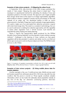
Figure 2 depicts the segmentation labels produced by the PSPNet
(Pyramid Scene Parsing Network ) and the Random Forest machine learning
8
9
methods . Challenges in the learning of these methods are that green
vegetation will be less prevalent in autumn and winter months, and that not
all tree species are green and not all green objects are trees. The PSPNet model
is robust to all of these.
Figure 2: Comparison of vegetation segmentation methods, from left to right: ground-truth
(Mapillary data), PSPNet, Random Forest, a* threshold. Images copyright Mapillary
Examples of data science projects – (2) Using mobile phone data for
tourism statistics
Another example is the use of mobile phone data. Mobile phones send
and receive signals from cell towers about 30 to 100 times a day with the only
condition that the phone is turned on. Those signals constitute valuable
information, which can be made into estimates about population density at
any time of the day, can determine commuting partners, determine
8 See https://hszhao.github.io/projects/pspnet/
9 See https://datasciencecampus.ons.gov.uk/wp-content/uploads/sites/10/2018/09/ons-dsc-
mapping-the-urban-forest.pdf
308 | I S I W S C 2 0 1 9