
Page 295 - Contributed Paper Session (CPS) - Volume 4
P. 295
CPS2230 Braden P. et al.
how thinning can simplify both internal and external boundaries, as well as
removing small islands that would hold no value in the final map.
4.2 Filter Islands
In most cases, the thinning step described in Section 4.1 would remove
any regions that would otherwise be affected by this function. However, this
step does exist as a valid option for cases where further thinning would
remove regions that should be kept in the final shapefile. This option allows a
user to retain more of the original geographically correct shapefile, but still
filter out islands that carry no meaning in the context of LMplots.
4.3 Moving Regions
There are two cases where we need to move regions around to be in a
more meaningful location for interpreting the spatial trend shown by a linked
micromap plot.
4.3.1 Moving Detached Regions
In cases where an island (island, here, refers to both the geographic
definition of a body of land surrounded by water and to a region of a country
that may completely be surrounded by a different country or other geographic
feature) that lies far outside the mainland region, the plotting region is
stretched and causes the entire region to appear smaller.
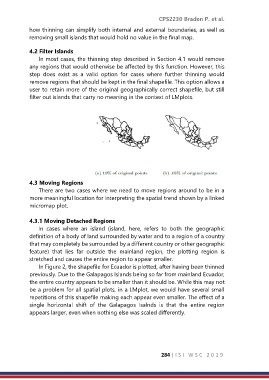
In Figure 2, the shapefile for Ecuador is plotted, after having been thinned
previously. Due to the Galapagos Islands being so far from mainland Ecuador,
the entire country appears to be smaller than it should be. While this may not
be a problem for all spatial plots, in a LMplot, we would have several small
repetitions of this shapefile making each appear even smaller. The effect of a
single horizontal shift of the Galapagos Isalnds is that the entire region
appears larger, even when nothing else was scaled differently.
284 | I S I W S C 2 0 1 9