
Page 296 - Contributed Paper Session (CPS) - Volume 4
P. 296
CPS2230 Braden P. et al.
4.3.2 Moving Small Regions Outside of the Boundaries
Another instance that may require us to move a region is where a region
is so small compared to the regions surrounding it that in its unchanged state
it is either hard to see or not visible at all. Such is the case of many city-states
and federal districts within countries.
To fix this issue, a small region may be better represented as an “island”
outside of a country’s boundaries. In order to do this, it is likely not a fix that
can use the same approach we used to fix the sizing issues that the Galapagos
Islands caused in the Ecuador shapefile. In order to accomplish this in a
meaningful way, we will not only have to enlarge a region but also change the
coordinates of a region to have it show up adjacent to the main land.
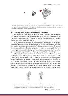
In Figure 3, the region of Littoral is the main urban area in Benin, a country
in Western Africa. When plotting without modifications, the region is barely
visible along the southern border. Further, if we were to simply enlarge the
region in this case, by the time is was large enough for plotting, it would be
masking the surrounding regions. By representing the region as an “island”,
we are able to make the region much more visible without intruding on the
visibility of surrounding regions. As this modification may not be ideal,
particularly to locals in the region, this is meant to be viewed as one possible
285 | I S I W S C 2 0 1 9