
Page 297 - Contributed Paper Session (CPS) - Volume 4
P. 297
CPS2230 Braden P. et al.
solution addressing the fact that simply enlarging the region would cause
other issues that may not be as easy to fix.
4.4 Enlarging Regions
In some countries, we may have some regions that are hard to see when
plotted in LMplots, but that are surrounded by large regions. In these types of
cases, it is possible to address the small regions without having to change too
much of the underlying shape of the shapefile. In these cases, we can enlarge
the areas of the smaller regions into the larger surrounding regions.
When enlarging a region in Mapshaper, the scaling of a region is centered
at the midpoint of the original region. This process does not save the existing
borders between two neighboring regions and instead, the enlarged region
and all of its neighbors now have overlapping borders. In order to correct this,
we first shift the enlarged region to the location we desire and then cut out a
hole in the existing region, effectively removing parts of the surrounding
polygons and, by extension, the overlap caused by the enlarging of a region.
We can then put our modified enlarged region in the hole that we had
previously cut out.
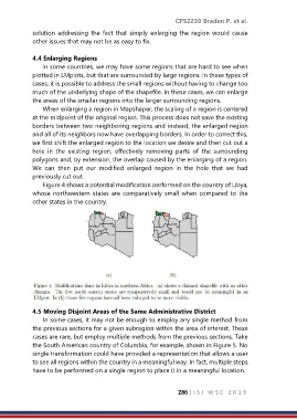
Figure 4 shows a potential modification performed on the country of Libya,
whose northwestern states are comparatively small when compared to the
other states in the country.
4.5 Moving Disjoint Areas of the Same Administrative District
In some cases, it may not be enough to employ any single method from
the previous sections for a given subregion within the area of interest. These
cases are rare, but employ multiple methods from the previous sections. Take
the South American country of Columbia, for example, shown in Figure 5. No
single transformation could have provided a representation that allows a user
to see all regions within the country in a meaningful way. In fact, multiple steps
have to be performed on a single region to place it in a meaningful location.
286 | I S I W S C 2 0 1 9