
Page 95 - Contributed Paper Session (CPS) - Volume 7
P. 95
CPS2036 Mahdir B. et al.
Figure 5: Google Earth (KML format)
iv. or sample of plantations, the EBs which touches the boundary of the
particular land title is listed as a MEB. All adjacent EBs will be identified
as potential PEB. Only one PEB will be chosen using simple random
sampling method for each MEB.
v. For Smallholders, the EBs which touches the boundary of the particular
land title is listed as selected EBs.
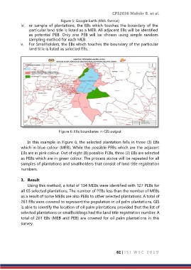
Figure 6: EBs boundaries in GIS output
In this example in Figure 6, the selected plantation falls in three (3) EBs
which in blue colour (MEB). While the possible PEBs which are the adjacent
EBs are in pink colour. Out of eight (8) possible PEBs, three (3) EBs are selected
as PEBs which are in green colour. The process above will be repeated for all
samples of plantations and smallholders that consist of land title registration
numbers.
3. Result
Using this method, a total of 134 MEBs were identified with 127 PEBs for
all 65 selected plantations. The number of PEBs less than the number of MEBs
as a result of some MEBs are also PEBs to other selected plantations. A total of
261 EBs were covered to represent the population in oil palm plantations. GIS
is able to identify the location of oil palm plantations provided that the list of
selected plantations or smallholdings had the land title registration number. A
total of 261 EBs (MEB and PEB) are covered for oil palm plantations in this
survey.
82 | I S I W S C 2 0 1 9