
Page 96 - Contributed Paper Session (CPS) - Volume 7
P. 96
CPS2036 Mahdir B. et al.
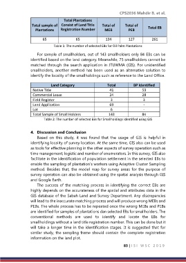
Total Plantations
Total sample of Consist of Land Title Total of Total of
Plantations Registration Number MEB PEB Total EB
65 65 134 127 261
Table 1: The number of selected EBs for Oil Palm Plantations
For sample of smallholders, out of 143 smallholders only 84 EBs can be
identified based on the land category. Meanwhile, 75 smallholders cannot be
matched through the search application in JTUWMA (GIS). For unidentified
smallholders, another method has been used as an alternative solution to
identify the locality of the smallholdings such as reference to the Land Office.
Land Category Total BP Identified
Native Title 41 53
Commercial Lease 24 28
Field Register 3 3
Land Application 69 -
Lot 6 -
Total Sample of Small Holders 143 84
Table 2: The number of selected EBs for Smallholdings Identified using GIS
4. Discussion and Conclusion
Based on this study, it was found that the usage of GIS is helpful in
identifying locality of survey location. At the same time, GIS also can be used
as tools for effective planning in the other aspects of survey operation such as
time management, logistic and number of enumerators. In this survey, GIS also
facilitate in the identification of population settlement in the selected EBs to
enable the sampling of plantation’s workers using Adaptive Cluster Sampling
method. Besides that, the model map for survey areas for the purpose of
survey operation can also be obtained using the spatial analysis through GIS
and Google Earth.
The success of the matching process in identifying the correct EBs are
highly depends on the accurateness of the spatial and attributes data in the
GIS database of the Sabah Land and Survey Department. Any discrepancies
will lead to the inaccurate matching process and will produce wrong MEBs and
PEBs. The whole process has to be repeated once the wrong MEBs and PEBs
are identified for samples of plantations dan selected EBs for smallholders. The
conventional methods are used to identify and locate the EBs for
smallholdings without a land title registration number. This can be done but it
will take a longer time in the identification stages. It is suggested that for
similar study, the sampling frame should contain the complete registration
information on the land plot.
83 | I S I W S C 2 0 1 9