
Page 326 - Special Topic Session (STS) - Volume 4
P. 326
STS700 Candigo J. A., Jr. et al.
modal transport linkages and digital infrastructure. It is on this premise that
the RAI was computed for Davao Region.
Using 2015 population data, Table 1 shows the Rural Access Index of the
five provinces of Davao Region:
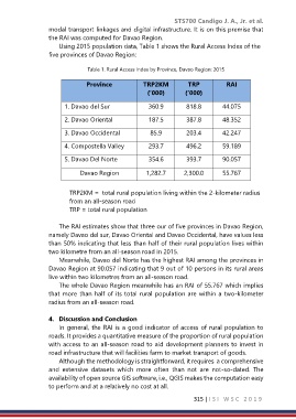
Table 1. Rural Access Index by Province, Davao Region: 2015
Province TRP2KM TRP RAI
(‘000) (‘000)
1. Davao del Sur 360.9 818.8 44.075
2. Davao Oriental 187.5 387.8 48.352
3. Davao Occidental 85.9 203.4 42.247
4. Compostella Valley 293.7 496.2 59.189
5. Davao Del Norte 354.6 393.7 90.057
Davao Region 1,282.7 2,300.0 55.767
TRP2KM = total rural population living within the 2-kilometer radius
from an all-season road
TRP = total rural population
The RAI estimates show that three our of five provinces in Davao Region,
namely Davao del sur, Davao Oriental and Davao Occidental, have values less
than 50% indicating that less than half of their rural population lives within
two kilometre from an all-season road in 2015.
Meanwhile, Davao del Norte has the highest RAI among the provinces in
Davao Region at 90.057 indicating that 9 out of 10 persons in its rural areas
live within two kilometres from an all-season road.
The whole Davao Region meanwhile has an RAI of 55.767 which implies
that more than half of its total rural population are within a two-kilometer
radius from an all-season road.
4. Discussion and Conclusion
In general, the RAI is a good indicator of access of rural population to
roads. It provides a quantitative measure of the proportion of rural population
with access to an all-season road to aid development planners to invest in
road infrastructure that will facilities farm to market transport of goods.
Although the methodology is straightforward, it requires a comprehensive
and extensive datasets which more often than not are not-so-dated. The
availability of open source GIS software, i.e., QGIS makes the computation easy
to perform and at a relatively no cost at all.
315 | I S I W S C 2 0 1 9