
Page 112 - Contributed Paper Session (CPS) - Volume 7
P. 112
CPS2042 Anna Christine D. et al.
area planted in rice under the rice crop- cutting pilot survey methodology.
These estimates can also be used for improving the level of precision of the
estimates of total rice paddy production through ratio estimation.
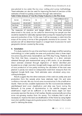
Table 8: Ratio Estimate of Total Rice Paddy Production in the Pilot Areas
95% confidence interval
Domain Estimate, kg SE CV
Lower Upper
Savannakhet 693,823,889 93,955,279 0.135 521,700,609 890,005,302
Ang Thong 141,362,508 14,234,430 0.101 114,827,845 170,626,811
Thai Binh 395,857,496 28,887,778 0.073 337,361,510 450,601,602
The measures of precision and design effects in the three provinces
determined in this study can be useful for determining the sample size that
would be needed for nationally representative surveys for measuring the total
area and production of rice. In this case, it will be necessary to determine the
scope of the survey in terms of the geographic domains to be covered. The
sample size will be determined based on a target level of precision for each
geographic domain covered by the survey.
4. Conclusion
This study explores the use of an area frame multi-stage stratified sampling
methodology to collect paddy rice area and production data in three major
rice-producing pilot areas: Savannakhet, Lao PDR; Ang Thong, Thailand; and
Thai Binh, Viet Nam, comparing three approaches: (i) a direct estimate
obtained through plot measurement using a GPS device, (ii) an alternative
direct estimate obtained through digitization of farmer identified plot
boundaries on a high-resolution Google Earth image, and (iii) a ratio estimate
of total production of rice paddy involving the calculation of the total area
planted in paddy rice based on independent mesh-level measures from the
digitized Google Earth map. Yield estimates were calculated using crop-
cutting techniques.
Results suggest that the direct estimates of the total rice paddy area and
production from the sample plots have relatively high CVs and wide
confidence intervals. We also found some inconsistencies in the stratification
results. There are two possible explanations for the inconsistencies between
satellitebased land cover classification and what was found during the
fieldwork: (i) the power of discrimination in the satellite imagery and
stratification might not be sufficient or (ii) field teams might not have
accurately reported the status of all meshes, thereby systematically excluding
some rice-growing meshes from the survey. This indicates that it will be
necessary to improve the land use stratification of the frame by using higher
resolution satellite images and a greater power of discrimination in the models
used for defining the strata.
99 | I S I W S C 2 0 1 9