
Page 290 - Contributed Paper Session (CPS) - Volume 2
P. 290
CPS1857 Nicholas J. et al.
For testing the accuracy of the regression models, we wil map the training
data (input) and represent the mapping result for each pixels of the training
data into the multi-dependent variable. We compare the results of the
classification to the initial multi-dependent variables that has been
determined in the training process. The result of the testing process indicates
that the models provide a high accuracy for the training data. The models give
the average accuracy of 96.60% (Table 3).
Table 3. Accuracy Regression Models
Land Type Accuracy (%) Error (%)
Impervious 99.20 0.80
Table 3. Accuracy Regression Models
Land Type Accuracy (%) Error (%)
Green 89.16 10.83
Water 98.96 1.04
Soil 99.32 0.68
Average 96.60 3.40
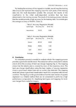
4. Conclusion
An evaluation process is needed to evaluate wheter the mapping process
provides a good and realible result. The evaluation will be conducted in Jakarta
area to show the accuracy of land-use change mapping (Fig. 4). The mapping
shows that the Jakarta area is covered by most of the impervious land. The
land-use change classification using the least median of squares regression
shows a good result where there are no outliers that detected. The mapping
result also shows a good land classification result if it’s compared with the real
condition. The figures provide good evidence that the least median of squares
regression is a reliable method that can be considered to performa a high
performance computation for classifying land types and mapping the land-
use changes from a satellite imagery.
279 | I S I W S C 2 0 1 9